

Kilclooney Mountain [Fauscoum]
Good walks are even better shared.
S3110 : Summit Cairn
kevin higgins Photo source
Overview
Kilclooney Mountain, also known as Fauscoum, is the 792 m high point of the Comeragh Mountains in County Waterford. A cairn marks its broad, boggy plateau summit above Coumshingaun. Reaching the cairn requires a separate detour from the corrie rim; the ridge circuit involves exposed scrambling and serious mountain navigation.
Kilclooney Mountain [Fauscoum]
Kilclooney Mountain, also known as Fauscoum, is the 792 m high point of the Comeragh Mountains in County Waterford. A cairn marks its broad, boggy plateau summit above Coumshingaun. Reaching the cairn requires a separate detour from the corrie rim; the ridge circuit involves exposed scrambling and serious mountain navigation.
Summit identity
A cairn marks the 792 m high point at Irish Grid S 31699 10505. The summit is on the broad Comeragh plateau, inland from the cliffs above Coumshingaun, and requires a deliberate detour from the corrie-rim route.
Route from Kilclooney Wood
Start and finish at Kilclooney Wood car park beside the R676. Follow the woodland paths and forest track past the mast, then the approach towards the prominent boulder below the southern ridge of Coumshingaun. Climb the rocky southern ridge, including the steep exposed scramble below the plateau. Leave the rim and navigate west across boggy ground to the Fauscoum summit cairn. Retrace to the rim, continue north and east around the corrie, and descend the northern spur through rough ground and boulders. Stay on the spur until beyond the cliffs rather than cutting down early towards the lake. Cross the lower corrie and take the rising traverse back to the southern approach, then retrace through the woods to the same car park. The Carrignagower extension and Mahon Falls traverse are separate outings.
Other routes
A lake-only return does not reach Fauscoum. Continuing across the plateau to Carrignagower, called Fauscoum N Top in an older guide, makes a longer circuit. Mahon Falls offers a separate approach via Knockaunapeebra; the published routes involve steep ground and river crossings, and the river may be impassable after heavy rain. A traverse ending at Mahon Falls car park needs onward transport. These options are not included in the circuit described above.
Terrain and safety
Woodland tracks and rough approach paths lead to steep rocky ridges around Coumshingaun. The southern ridge has scrambling and an exposed final climb to the plateau; the northern descent includes boulders and uneven heathery ground. The summit detour crosses peaty, often boggy plateau terrain.
- The southern Coumshingaun ridge includes hands-on scrambling and a steep exposed section just below the plateau, with major drops nearby.
- The corrie rim lies above high cliffs. Do not approach the edge or follow an unplanned gully when visibility is poor.
- The northern descent passes through steep bouldery and uneven ground. Leaving the spur too early can lead onto cliffs above the lake.
- The broad, boggy plateau has few distinctive landmarks. Locate the summit detour and the correct return to the rim using competent navigation rather than relying on a visible path.
- Wet or icy rock increases the seriousness of the ridge scrambling. Strong wind and low cloud can make exposed sections and route-finding particularly hazardous.
- Mahon Falls approaches are separate routes with steep ground and river crossings; the river may be impassable after heavy rain.
Rain can make rock and steep heathery ground slippery and worsen the boggy plateau. Snow or ice greatly increases the difficulty of the ridge scramble. Low cloud can obscure both the cairn detour and the correct descent; allow sufficient daylight for the full return.
Access and parking
Use the Coillte Kilclooney Wood car park beside the R676 for the described circuit (MountainViews start grid S34106 10222). Keep forest access clear and follow local signs. Current charges, gate times and vehicle-height limits have not been verified. A Waterford Council notice dated 31 July 2026 asked walkers to avoid Kilclooney and Coumshingaun while firefighting continued. No later official status confirmation was found in this review; check current Council and Coillte notices and local signs before travelling. Much of the Comeragh uplands is private or commonage land, and access depends on landowner goodwill. Dungarvan Tourism states that dogs are not permitted on Comeragh upland walks. Leave dogs at home for this outing, respect landowners and follow current local restrictions.
Transport and facilities
No direct public-transport service to Kilclooney Wood car park was verified. Check TFI Local Link Waterford and the TFI journey planner for your date, then arrange onward transport and a return after the mountain walk. Services to Mahonbridge or Rathgormack do not by themselves establish access to this trailhead.
Coillte lists a car park, picnic site and walking trails at Kilclooney Wood. Toilets, drinking water and refreshments at the trailhead have not been verified, so plan food, water and stops before setting out. Dungarvan is identified by Coillte as a nearby service destination.
Geology
The Comeragh plateau and corries expose Devonian Old Red Sandstone rocks, including coarse conglomerates. MountainViews identifies the summit bedrock as green, thick-bedded conglomerate of the Treanearla Formation. Glacial erosion cut Coumshingaun into the eastern mountainside, leaving steep arêtes on its sides and a lake behind an eastern moraine.
Views and surroundings
In clear weather the summit area looks across the Comeraghs towards the Knockmealdown Mountains, the Waterford lowlands and the coast. The views down into Coumshingaun are from the corrie rim, which is separate from the plateau cairn. Coumshingaun corrie and lake lie below the eastern plateau edge. Coum Iarthar is to the north; Mahon Falls and Coummahon are to the south. Visiting these features may require a different route or an extension.
Names and history
MountainViews gives Fáschom as 'empty hollow'. The name properly refers to the coom immediately south of Coumshingaun and may describe its wild character or lack of a lake. Kilclooney Mountain takes its name from the townland containing the summit. Kilclooney Wood, used on the main approach, was formerly part of the Curraghmore Estate. The summit itself is a plateau high point; the most distinctive surrounding heritage is the glacial landscape of Coumshingaun.
Explore routes near Kilclooney Mountain [Fauscoum]
Walks starting near this hill. Open a route to check its map, distance and full itinerary.
Route planning notes
These notes describe possible approaches. Check a route's map and access information when planning your walk.
Coumshingaun circuit with Fauscoum summit detour
Start and finish at Kilclooney Wood car park beside the R676. Follow the woodland paths and forest track past the mast, then the approach towards the prominent boulder below the southern ridge of Coumshingaun. Climb the rocky southern ridge, including the steep exposed scramble below the plateau. Leave the rim and navigate west across boggy ground to the Fauscoum summit cairn. Retrace to the rim, continue north and east around the corrie, and descend the northern spur through rough ground and boulders. Stay on the spur until beyond the cliffs rather than cutting down early towards the lake. Cross the lower corrie and take the rising traverse back to the southern approach, then retrace through the woods to the same car park. The Carrignagower extension and Mahon Falls traverse are separate outings.
Make a day of it, together
Find someone to share the walk with, or organise a day out along a route you like.
Photo Gallery
View all Photo could not load
S3110 : Summit Cairn
kevin higgins
 Photo could not load
S3110 : Summit Cairn
kevin higgins
 Photo could not load
S3110 : Summit cairn Fauscoum, Comeragh Mountains
Colin Park
Hill facts and local notes
Classifications
Elevation
792m
2,598 ft
Prominence
628m
Coordinates
52.2458, -7.5367
S316105
OS Map
75
At the Summit
A cairn marks the 792 m high point at Irish Grid S 31699 10505. The summit is on the broad Comeragh plateau, inland from the cliffs above Coumshingaun, and requires a deliberate detour from the corrie-rim route.
Terrain & Geology
The Comeragh plateau and corries expose Devonian Old Red Sandstone rocks, including coarse conglomerates. MountainViews identifies the summit bedrock as green, thick-bedded conglomerate of the Treanearla Formation. Glacial erosion cut Coumshingaun into the eastern mountainside, leaving steep arêtes on its sides and a lake behind an eastern moraine.
Views & Scenery
In clear weather the summit area looks across the Comeraghs towards the Knockmealdown Mountains, the Waterford lowlands and the coast. The views down into Coumshingaun are from the corrie rim, which is separate from the plateau cairn.
History & Heritage
Name Origin
MountainViews gives Fáschom as 'empty hollow'. The name properly refers to the coom immediately south of Coumshingaun and may describe its wild character or lack of a lake. Kilclooney Mountain takes its name from the townland containing the summit.
Historical Significance
Kilclooney Wood, used on the main approach, was formerly part of the Curraghmore Estate. The summit itself is a plateau high point; the most distinctive surrounding heritage is the glacial landscape of Coumshingaun.
Getting There & Facilities
Parking
Use the Coillte Kilclooney Wood car park beside the R676 for the described circuit (MountainViews start grid S34106 10222). Keep forest access clear and follow local signs. Current charges, gate times and vehicle-height limits have not been verified. A Waterford Council notice dated 31 July 2026 asked walkers to avoid Kilclooney and Coumshingaun while firefighting continued. No later official status confirmation was found in this review; check current Council and Coillte notices and local signs before travelling. Much of the Comeragh uplands is private or commonage land, and access depends on landowner goodwill. Dungarvan Tourism states that dogs are not permitted on Comeragh upland walks. Leave dogs at home for this outing, respect landowners and follow current local restrictions.
Public Transport
No direct public-transport service to Kilclooney Wood car park was verified. Check TFI Local Link Waterford and the TFI journey planner for your date, then arrange onward transport and a return after the mountain walk. Services to Mahonbridge or Rathgormack do not by themselves establish access to this trailhead.
Nearby Facilities
Coillte lists a car park, picnic site and walking trails at Kilclooney Wood. Toilets, drinking water and refreshments at the trailhead have not been verified, so plan food, water and stops before setting out. Dungarvan is identified by Coillte as a nearby service destination.
Safety Information
Known Hazards
- The southern Coumshingaun ridge includes hands-on scrambling and a steep exposed section just below the plateau, with major drops nearby.
- The corrie rim lies above high cliffs. Do not approach the edge or follow an unplanned gully when visibility is poor.
- The northern descent passes through steep bouldery and uneven ground. Leaving the spur too early can lead onto cliffs above the lake.
- The broad, boggy plateau has few distinctive landmarks. Locate the summit detour and the correct return to the rim using competent navigation rather than relying on a visible path.
- Wet or icy rock increases the seriousness of the ridge scrambling. Strong wind and low cloud can make exposed sections and route-finding particularly hazardous.
- Mahon Falls approaches are separate routes with steep ground and river crossings; the river may be impassable after heavy rain.
Seasonal Hazards
Rain can make rock and steep heathery ground slippery and worsen the boggy plateau. Snow or ice greatly increases the difficulty of the ridge scramble. Low cloud can obscure both the cairn detour and the correct descent; allow sufficient daylight for the full return.
General Safety Tips
- Check weather conditions before setting out
- Carry appropriate clothing and equipment
- Let someone know your planned route
- Take a map, compass, and GPS device
- Carry emergency supplies: food, water, first aid kit, torch
Hills
Some common questions about the hills answered
Are there group walks up Kilclooney Mountain [Fauscoum]?
Many walkers use Walkmates to join or organise walks with others. You can check for group walks around Kilclooney Mountain [Fauscoum] through the maps
Are there other walkers around Kilclooney Mountain [Fauscoum]?
Activity varies by location and time, but Walkmates lets you see whether others have shared walks or shown interest in this area. Find other people through the walking friends search walking friends for Kilclooney Mountain [Fauscoum] search or of course create your own walk for Kilclooney Mountain [Fauscoum]
Can I organise a walk to Kilclooney Mountain [Fauscoum]?
Yes. If there aren’t any walks listed already, you can create a walk and make it available for others to join.
If you're signed up to Walkmates, you can create a walk to Kilclooney Mountain [Fauscoum].
How do I find a walk up this hill?
There are often multiple ways to walk this hill, depending on experience and route preference. Walkmates helps you explore walks and routes that others have shared.
Can I suggest a new route up Kilclooney Mountain [Fauscoum]?
Yes. You can suggest or create routes to share with others. Walkmates focuses on the social side of walking, so routes are used to help people organise walks and explore areas together, rather than as detailed navigation tools or route libraries.
Other uses really appreciate knowledgeable walkers sharing their routes. Share your favourite route to Kilclooney Mountain [Fauscoum] here
The is an error or something incorrect about this hill. How do I let you know?
We always strive to keep the information on Walkmates as accurate as possible. If you find an error, please let us know through the contact form and we'll aim to correct it as quickly as possible
Community Discussion
Comments
Location
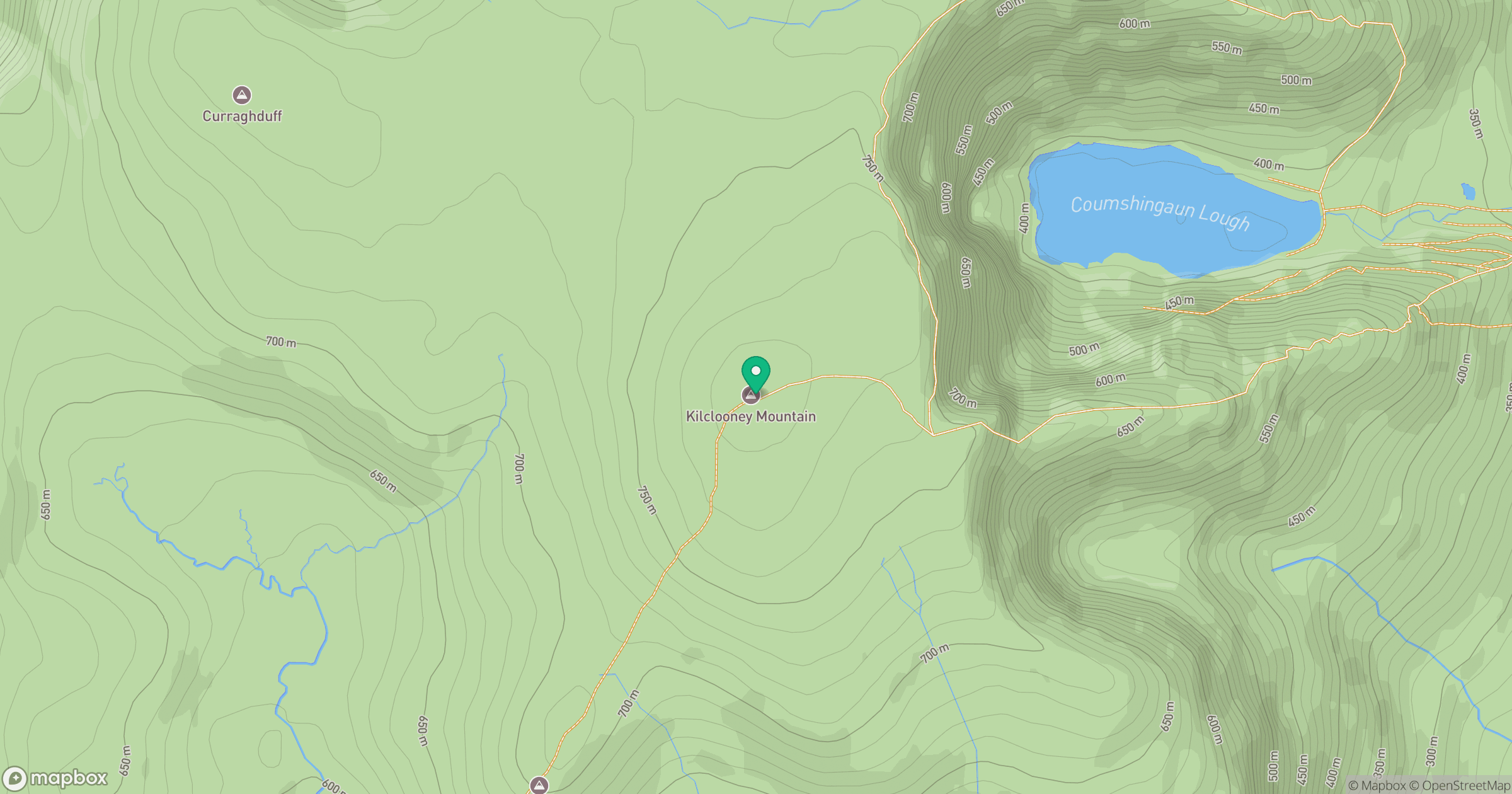
Grid reference: S316105
View on OpenStreetMapOpens a map in a new tab, centred on the hill.
No comments yet. Be the first.